
 One premise of David Flynn's “Temple at the Center of Time” principle is, simply stated, that the number of nautical miles from the Temple Mount to a particular location relates to when an important event happened there, one nautical mile for each year AD. This has been very useful to me in a special project I have going and I wanted to give tribute to David's memory by sharing one of the validating features I discovered.
 I don't have any idea if I'm the first, second or millionth to discover this, and this "discovery" may even be in David's book. I can't say I know because I only skimmed it some time ago to quickly derive just what the Lord had for me at that time. I did discover it in the sense of “new to me” while working on one of my projects, so, whether it's old news or new, I thought I would share it with you. (Thanks Lord, for brother David's labors!)
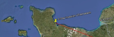
In my study, my thoughts had turned to the D-Day Invasion of WWII. Using Google Earth and the line tool, an line drawn from the Temple Mount at the precise distance equating to the D-Day invasion can be swung to "land on" Normandy's UTAH beach. Exactly.
Here's some images. This first one is a map of the invasion (called Operation Overlord) that took place on June 6, 1944 - D-Day. (map of invasion)

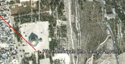
This image of the Temple Mount shows the line's point or origin.
This image shows where an arc of that radius sweeps to make landfall on Europe. It lands in France, in Normandy, on the beach known today as UTAH beach.
If you compare this to the invasion map, you'll see that is the very focal point of the invasion force.
 What was quite probably the most historically significant event on that date happened right there!
 Check it for yourself, if you like. To calculate the distance from the Temple Mount to use for the line length, June 6, 1944 becomes 1944.43 nautical miles. It was a leap year, and June 6 was day 158 of 366. 158/366=.43
[UPDATE] Here's a tool that converts GPS coordinates of your target location directly into the corresponding date. Temple at the Center of Time - Conversion Tool
David Flynn's work is much appreciated. To everyone who supported his efforts, thank you!
Is this related to the 1948 miles from Jerusalem to London theme (1948 year of Isreal becoming a nation/also 1948 the last year of the London Olympics?)
ReplyDeleteThe principle is the same. That wasn't the project I was working on, but it is certainly pertinent!
ReplyDeleteThe Zion Olympics * the London-Israel link made through the Temple Mount time-distance measurement * William Blake's poem "Jerusalem"
I am told this isn't in his book. I looked through the book myself much more thoroughly last night, not looking specifically for D-Day and a UTAH beach correlation, but didn't happen to see it during my time with it. I did happen to see many things I consider valuable nuggets, for which I'm still praising the Lord!
ReplyDeleteKing James Bible
ReplyDeleteTo every thing there is a season, and a time to every purpose under the heaven:Ecclesiastes 3:1